Combined Sewer Flooding in Rhondda Cynon Taf Area
Dwr Cymru drainage has a combined storm overflows system, which means it is allowed to discharge sewage direct in to our rivers so just how clean are our rivers in Cynon Valley? Why do Dwr Cymru dump sewage into our rivers and is the problem getting worse?
After a freedom of information request Dwr Cymru informed AberdareOnline the main sewer pipeline that carries waste from our lavatories that the sewer that runs through the Cynon catchment area varies in size as from 750 mm under 30 inches wide to 1200 mm 47 inches just under 4 ft. wide The waste from this sewer is treated at Cynon wastewater treatment works.
The capacity of Cynon’s sewer system is only as good as its narrowest point in the pipeline irrespective if the main sewer is larger in places 47 inches, common sense will tell you can't put a gallon of water into a half-gallon jar or a 30” pipe the surplus in this case sewage has to go somewhere.
AberdareOnline again under the freedom of Information Act received this response from Dwr Cymru. ‘The main sewer out of Cynon Valley was constructed in the early 1930s and the diameter 57 inches (1200mm) (= 47”). The operation of our combined sewer overflow (CSOs)
(A combined sewer overflow is a pipeline that discharges sewage into the river if the pipeline get overloaded) this is regulated, permitted and monitored by Natural Resource Wales (NRW) and Environmental Agency (EA).
There are two CSO’s that discharge to the River Dare, five to the River Aman and 46 to the River Cynon via some smaller tributaries.” Below you can find the data for the year 2020 by Welsh Water for Cynon Valley.
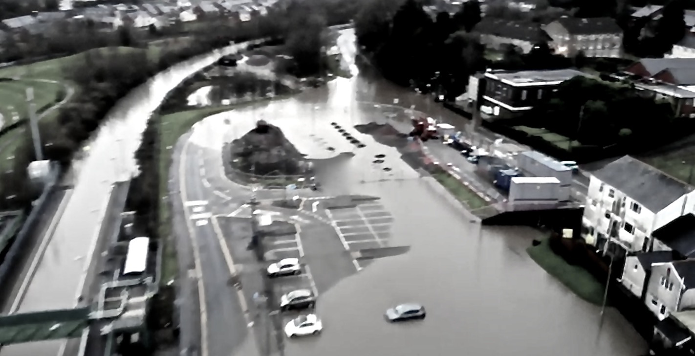
There doesn’t appear to be any major improvements planned for the Cynon Valley main sewer system but Rhondda Cynon Taf Council Planning Department keeps allowing more and more large developments and Dwr Cymru and Natural Resources Wales find no objection to building more houses knowing the existing drainage system is not fit for purpose and Dwr Cymru has provided information that 293 locations at risk of sewer flooding at varying locations across the authority.
Combine this with the sewer overflow into our rivers 46 to the River Cynon alone without all the others. Is there a better reason why neither the labour members at the Senedd and labour councillors at Rhondda Cynon Taf Council do not want a Public Inquiry into past flooding events?
The National Rivers Authority (NRA) was one of the forerunners of the Environment Agency of England and Wales, existing between 1989 and 1996 now Welsh Rivers under the protection by NRW, but when the NRA were responsible they were concerned about overdevelopment a report they produced in April 1995 explaining.
“The floodplain is an integral part of the overall river system and the NRA considers it essential that they are kept free from development for flood defence reasons.”
The areas of floodplain under threat from development are all low-lying land flanking the River Cynon downstream from Pontcynon to the low-lying road bridge crossing in Abercynon (the Abercynon Leisure Centre which is periodically surrounded by floodwater to a depth of 0.5m) the wide, well-established areas between Peace Park and Aberdare. Tir Founder Fields, Cwmbach a large floodplain that the council gave outline planning permission Ref 01/4020/13, granted on 21 December 2005, you have to ask the question why did the labour controlled council grant planning permission having the full knowledge of the report by NRA before any decisions were made, flooding has increased since the development by Persimmon on Tir Founder Fields site.
The report goes on to explain, these floodplains could severely exacerbate flood risks to Mountain Ash and impair the efficiency of recent schemes. The River Cynon channel in this Development of these is being pursued by the WDA and Cynon Valley Borough Council under the Cynon Valley Joint Venture Group. Any significant loss of these floodplains could severely exacerbate flood risks to Mountain Ash and impair the efficiency of recent schemes. The River Cynon channel in this reach has been grossly affected by mining subsidence such that the remaining capacity of the floodplain area is critical.
The land, which lies between Pontypridd and the confluence of the River Taff and Nant Clydach, has attracted considerable interest from developers in recent years. It is an important flood storage feature and its loss would increase the flood risk to areas downstream, including the recently constructed flood defences at Pontypridd.
The NRA report on Environmental Requirements
Physical Features In protected areas; the flood defences/riverbank should not be overtopped by a flood flow within a specified return period.
In areas where land use is primarily agricultural, the watercourse should provide effective drainage, taking into account environmental requirements.
No development should be permitted which would impair the effectiveness of any flood defence scheme or prevent access for maintenance of flood defences.
The recent flooding at Mountain Ash the report explains Mountain Ash
“Part 1 o f a 2-part scheme to improve the River Cynon through Mountain Ash was carried out by Cynon Valley Borough Council in 1992/93.
This first part will not give full protection until river improvements in Part 2 are effected.
The GLFDC contributed approximately £380,000 to this scheme and have agreed to assume maintenance responsibilities for the new channel and defences.
DEVELOPMENT USES
In the late 1980s, Mid Glamorgan Land Reclamation Department carried out major channel improvements upstream of the road bridge in Mountain Ash.
The channel will not be wholly effective until the constrictive main road bridge has been removed.”
The main road bridge has been removed? The forward-thinking of the Mid Glamorgan County Council was to construct two new river crossings in Mountain Ash the Southern Link road that has now been completed by RCTC and a Northern Link Road between the hospital and old town hall. Part of the a Northern Link road was carried out with the demolishing of buildings in readiness but the current labour leader of RCTC thinks this is a waste of public money.
Below taken from Rhondda Cynon Taf County Borough Council
Flood Risk Management Plan
VOLUME 1
Combined sewers within Rhondda Cynon Taf County Borough Council are under the ownership of Dwr Cymru Welsh Water. Combined sewers are underground conduits for the removal of drainage water and waste matter from source to treatment works.
Flooding arises from combined sewers when excess rainwater entering the system exceeds the capacity of the sewer.
Dwr Cymru Welsh Water have provided information that 293 locations at risk of sewer flooding at varying locations across the authority.
Rhondda Cynon Taf County Borough Council will look to work with Dwr Cymru Welsh Water to better understand the risks posed by combined sewer flooding and where the locations are.
FLOODPLAIN AREAS UNDER THREAT FROM DEVELOPMENT
The floodplain is an integral part of the overall river system and the NRA considers it essential that they are kept free from development for flood defence reasons. In addition, the NRA recognises the importance of protecting the existing aquatic environment and heritage features associated with them. Over the next 5 years, the NRA will be conducting a national survey of flood risk areas (in accordance with Section 105 of the Water Resources Act 1991) to further assist local authorities in their consideration of planning proposals and the need for flood alleviation works. The areas of floodplain under threat from development are: all low-lying land flanking the River Cynon downstream from
Pontcynon to the low-lying road bridge crossing in Abercynon (the Abercynon Leisure Centre which is periodically surrounded by floodwater to a depth of 0.5m) the wide, well-established areas between Peace Park and Aberdare.
Development of these is being pursued by the WDA and Cynon Valley Borough Council under the Cynon Valley Joint Venture Group. Any significant loss of these floodplains could severely exacerbate flood risks to Mountain Ash and impair the efficiency of recent schemes. The River Cynon channel in this reach has been grossly affected by mining subsidence such that the remaining capacity of the floodplain area is critical.
The land which lies between Pontypridd and the confluence of the
River Taff and Nant Clydach, has attracted considerable interest from developers in recent years. It is an important flood storage feature and its loss would increase the flood risk to areas downstream, including the recently constructed flood defences at Pontypridd
River Taff and Nant Clydach, has attracted considerable interest from developers in recent years. It is an important flood storage feature and its loss would increase the flood risk to areas downstream, including the recently constructed flood defences at Pontypridd.
Mountain Ash
Part 1 of a 2-part scheme to improve the River Cynon through Mountain Ash was carried out by Cynon Valley Borough Council in 1992/93.
This first part will not give full protection until river improvements in Part 2 are effected.
The GLFDC contributed approximately £380,000 to this scheme and have agreed to assume maintenance responsibilities for the new channel and defences.
DEVELOPMENT USES
In the late 1980s, Mid Glamorgan Land Reclamation Department carried out major channel improvements upstream of the road bridge in Mountain Ash.
The channel will not be wholly effective until the constrictive main road bridge has been removed.
There are areas of floodplain at Treforest, Pontypridd, Cilfynydd, Pontcynon, Abercynon and between Mountain Ash and Aberdare. These have an important role in the storage of floodwaters and should be protected from development which would reduce this capacity, thereby raising the flood risks to other areas.
The flood warning system covers most of the main towns and the environs in the catchments of the rivers Taff, Cynon and Rhondda.
Environmental Requirements
Physical Features In protected areas; the flood defences/riverbank should not be overtopped by a flood flow within a specified return period.
In areas where land use is primarily agricultural, the watercourse should provide effective drainage, taking into account of environmental requirements.
No development should be permitted which would impair the effectiveness of any flood defence scheme or prevent access for maintenance of flood defences.
Welsh Water 2020 data is below for Cynon Valley only the rest for South East Wales can be found on the link below
Name area Duration Releases Hours & Minutes per annum
Harriet Street Aberdare Trecynon 0 Hours 45 Minutes 3
Aberdare – Tudor Terrace 8 Hours 45 Minutes 15
Abernant – Forge Tip 31 Hours 15 Minutes 45
Aberdare – Monk Street 799 Hours 30 Minutes 138
Aberaman Enterprise Park 0 Hours 0 Minutes 0
Aberdare – Curre Street 58 Hours 30 Minutes 36
Incline Row Aberdare Aberaman 9 Hours 30 Minutes 5
Wellington St Robertstown 1 Hours 45 Minutes 3
Rhigos – Heol Pendarren 92 Hours 15 Minutes 54
Hirwaun – Merthyr Rd 1085 Hours 0 Minutes 118
Hirwaun – Trenant Street 186 Hours 30 Minutes 74
Tramroad Trenant Hirwaun 0 Hours 0 Minutes 0
Penywaun – Mangoed Gardens 3 Hours 15 Minutes 2
Hirwaun – Bute Place 96 Hours 30 Minutes 41
Ynysybwl Near Pit 928 Hours 30 Minutes 144
New Road Ynysbwl 211 Hours 15 Minutes 85
Fforchaman St Cwmaman 0 Hours 15 Minutes 1
Park View Abercwmboi 8 Hours 0 Minutes 9
Abercwmboi – Bronallt Terrace 793 Hours 30 Minutes 54
Cwmbach – Pant-y-Cerdin 219 Hours 15 Minutes 75
Cwmbach – Bronhaul 31 Hours 0 Minutes 18
Cwmbach – Bryngolwg 0 Hours 15 Minutes 1
Cwmbach – Crown Row 26 Hours 45 Minutes 13
Cwmbach – Bro Deg 177 Hours 0 Minutes 57
Cwmbach – Bro Deg 308 Hours 45 Minutes 102
Cwmbach – Sion Terrace 49 Hours 15 Minutes 27
Maeshyfryd 5 Hours 15 Minutes 7
Canal Rd Cwmbach 78 Hours 0 Minutes 26
Long Row Mountain Ash 39 Hours 0 Minutes 18
Mountain Ash – Hamilton St 0 Hours 0 Minutes 0
Duffryn Woods Mountain Ash 133 Hours 15 Minutes 35
Mountain Ash – New Road 157 Hours 15 Minutes 48
Miskin – Miskin Road 688 Hours 0 Minutes 123
Mountain Ash – Glasbrook 241 Hours 45 Minutes 70
Station Terrace Mountain Ash 71 Hours 30 Minutes 51
Pontcynon Pipe Bridge 1216 Hours 0
Town Hall Mountain Ash 32 Hours 30 Minutes 11
Aberaman – David Street 9 Hours 45 Minutes 5
Aberaman – Glancynon Terrace 5 Hours 30 Minutes 5
Clifton Crescent Aberaman 11 Hours 0 Minutes 21
Aberaman – Wind Street 57 Hours 15 Minutes 47
Cardiff Rd Aberaman 42 Hours 45 Minutes 41
Erw Las Aberdare 17 Hours 15 Minutes 27
Harriet St Llwydcoed 436 Hours 0 Minutes 94
Cwmdare – David St 0 Hours 0 Minutes 0
Merion St Aberdare 857 Hours 45 Minutes 121
Aberdare Elizabeth Street 91 Hours 0 Minutes 61
Aberdare Rugby Club 98 Hours 15 Minutes 39
Mikefield Aberman 1168 Hours 15 Minutes 94
Aberdare – Aberaman Ind Est 1718 Hours 15 Minutes 146
Cwmdare – Glan Road 51 Hours 45 Minutes 19
Aberaman – Cynon Street 2 Hours 30 Minutes 9
Aberaman – Fforchaman Street 0 Hours 15 Minutes 1
http://www.environmentdata.org/archive/ealit:3337/OBJ/20001882.pdf
https://www.walesonline.co.uk/news/wales-news/mountain-ash-flooding-storm-dennis-17758376
Related Posts

Unemployment rises to 5% in Wales, highest in 5 years, The lack of new infrastructure traffic queuing for miles on the M4 what business would want to invest in a business in South Wales.

Developments around Aberdare Town are there a lack of foresight in planning infrastructure around these developments?

The Welsh Government’s lack of infrastructure ambition
