Abercynon: a historical walk
This historical walk was kindly produced by Robert Jones of Carnetown Primary School in 2001
Abercynon Workmen’s Hall
The hall was built in 1905. It was for the workmen to better themselves. There was a reading room, library, meeting rooms and even a cinema. In 1906 there was a miners’ meeting there. It was addressed by the famous political leader, Keir Hardie. The Hall was demolished in 1994.
Ynysmeurig Farm
The land by the steps is the open land left after the development of Ynysmeurig Farm into houses. On the tithe map of 1846, the farm was owned by Meredith James. The land here was 1074 Y Waun – which was pasture and woodland, and 1075 Cae Galed – which was arable land. The farmhouse itself was situated on the flat land at the bottom of Ynysmeurig Road, probably at the back of the library.

Ynysmeurig Road
Looking up Ynysmeurig Road we can see the hill. This is known locally as Doctor’s Hill. It received this name when the local doctor Alexander Griffiths, at the beginning of the 1900s, moved his practice into the big house that stood at the junction of the hill and Edward Street. This road in 1845 led to Ynys Meurig Farm. It ended at the bottom of the steepest part of the hill.
The Railway Station

The railway came to Abercynon in the mid-1800s. The original railway was the Taff Vale Railway. This came from Cardiff to Merthyr on 12th April 1841. There was a branch leading to Aberdare in 1846. This meant that there had to be two stations in the town. The T.V.R. was taken over by the Great Western Railway in 1924 and this later became British Rail. Today it is Valley Lines. Both passenger and coal trains pass through Abercynon. Note the Junction Pub is named after the name of the first station – Aberdare Junction.
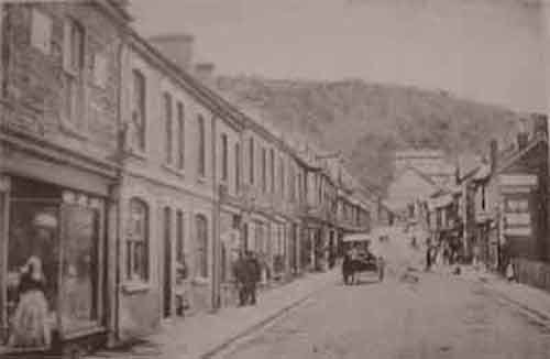
Margaret Street

Margaret Street is the main shopping street in Abercynon. It was developed on farmland as the town expanded with the development of the coal industry in the 1890s. Some of the shops still have what appears to be their original fronts. A good example is Griffiths’ shop front on the left as you walk up the street.
Park Street, Abercynon
This was the main way through the valley at the time of the 1846 tithe map. The road ran along the northwest side of the valley from the direction of Mountain Ash, down past Grovers’ Field and on towards Pontypridd. The line of the road today follows Mountain Ash Rd., Aberdare Rd. and Park Street.
Cross over and walk to St. Donat’s Church.
St. Donat’s Church, Abercynon

The Church was completed in 1898. It takes its name from St. Donat’s Castle on the south Wales coast. His was the home of the Stradling family who was the former owners of the Carne Park estate.
The church is unusual because it is aligned North to South instead of West to East. This is because of the slope of the ground. It would have been too expensive to build over. It has a main nave with a side aisle on the right. The south end has the altar and choir. At the north end is the font and there is a balcony. There is a tower with one bell on the northwest end of the church. Abercynon became a parish in 1908.