Part of the Railway embankment on the railway track from Abernant Station to the Cwmbach Railway tunnel
Most people in Cynon Valley when you mention the Abernant to Merthyr tunnel they say the Cwmbach tunnel but let’s not forget this section of the railway and its historical importance the railway was authorised by Act of Parliament on 3 August 1846. The first section to be opened was the main line from Neath to Gelli Tarw Junction, and the branch from there to Aberdare, on 24 September 1851. The line from Gelli Tarw to Merthyr Tydfil was opened on 2 November 1853.
Isambard Kingdom Brunel surveyed and prepared parliamentary plans for the Vale of Neath Railway which involved a 2,497-yard hole through the hill between Merthyr Tydfil and Aberdare, the second-longest of Wales' tunnels. 650 feet below ground at its deepest point, it was built to accommodate broad gauge and formed part of the 6¼-mile Gelli Tarw Junction-Merthyr extension, opening on 2nd November 1853. It regularly takes two names – Merthyr, which is to its east, and Abernant. http://www.forgottenrelics.co.uk/tunnels/gallery/merthyr.html
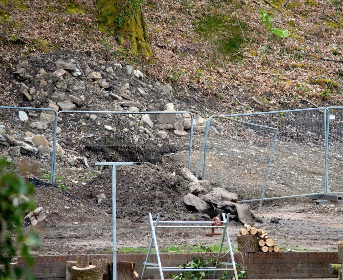
A history lesson as many of you will know the history already, because having received a copy of an email that concerned residents had contacted Rhondda Cynon Taf Legal Department with concerns over a new development that appears to have encroached into the embankment that protects part of this historic railway line.
Complying with UK Wildlife Legislation? Complying with tree protection?
From the content of the email received to encroach into the embankment mature oak trees were felled in the process apparently this was an established area for wildlife as the embankment was constructed around 1851 so oak trees would have been over 100 years old or more. The Ecological Report submitted to RCT Council for the site reads for the development.
A survey explains “There are a number of mature trees within the site boundary, some of which may contain roosting features for bats. The trees are out with the client's ownership and will be retained in their entirety.”
From a freedom of information request, having been informed the railway tunnel itself is owned by Highways England but not the old rail line now a public footpath maintained by RCT Council who I assume are also responsible for the embankment that supports the footpath. The council is said to be spending thousands on a feasibility study to reopen the railway tunnel that’s no good if the approach to the tunnel embankment is compromised. The Llewdcoed to Cwmbach footpath a project in 1988 a community program, the environmental project manager for the community programme back in 1985/88 said, he knows that area well. It was an environmental project he went on to explain I think the embankment could be classed as a grade 2 monument. Its age and design is of historical interest to loads of organisations. There's been a keep a lookout for decades for ancient strawberry plants. Miniature strawberry by today's standards but an old breed from Roman times. Know to frequent GWR era rail embankments.
So has the developer purchased part of the embankment? Or was the embankment his in the beginning before work started on the development? So what are the council doing about it perhaps they should look again at the planning application form submitted or don’t they bother to check the form or even
read what the applicant has written? I suggest they do with this planning application 20/0271/13 because what is written is not corresponding with the Ecological Report submitted to RCT Council.

Is this Complying with UK Wildlife Legislation? Complying with tree protection?
As planning application 07/1519 where the council allowed a developer to build on and block a Public Right of Way in Cwmaman the planning application said no PROW would be affected but it was.
The developer’s rule in Cynon Valley, do we have a weak-planning department? A council that is only interested in how much money it will gain from council tax on new developments?
I have been looking at RCT Planning and Development Committee reports but can find no information where this proposed development at Cenarth Drive Cwmbach as been fully passed by the Planning and Development Committee. So the question is has the development started without consent from the Planning and Development Committee? Or has someone in the planning department given consent for some interim work to be carried out?
The Ecological Report submitted to RCT Council I was informed that mature oak trees, which was perfect roosting features for bats a protected species the report continues Dormouse
“There is suitable habitat for dormice within the mature woodland adjacent to the site.
The woodland will be retained as it is out with the client's ownership. No further
surveys will be required in this instance.”
Rhondda Cynon Taf Council instruction
"A scheme for the provision of a protective barrier, including a scaled plan of the trees and location and extent of the barrier, for the purposes of preventing damage to the root protection area identified by Drawing Number 2719 NB, as received by the LPA on 7th May 2020. Such details shall also include confirmation that the barriers to be erected will be in accordance with the specifications detailed in figure 3 of BS5837:2012 ‘Trees in relation to design, demolition and construction – recommendations’; The protective barrier shall be erected in accordance with the approved details before any equipment, machinery or materials are brought onto the site for the purposes of the development, and shall be maintained until all equipment, machinery and surplus materials have been removed from the site. Nothing shall be stored or placed within any fenced area, and the ground levels within those areas shall not be altered, nor shall any excavation be made, without the prior written consent of the Local Planning Authority. Reason: In the interests of visual amenity and nature and landscape conservation in accordance with Policy AW8 of the Rhondda Cynon Taf Local Development Plan."
ECOLOGICAL APPRAISAL & BAT SURVEY APRIL 2020
“Woodland, hedgerows and fences
This habitat is found to the rear of the property on the northern, western and eastern boundaries.
Species within the woodland comprise of hazel, beech, oak, ash, sycamore, blackthorn with a complex but sparse understorey.
It is anticipated that all of this habitat will be retained. As a result of this, the woodland will not be mentioned in any detail other than in relation to protecting it from light spill and indirect impacts.
The woodland is already fenced off from the plot. However, if new fences are to be implemented as part of the development, they will be erected prior to the development commencing to ensure that there is no dumping of waste and to protect the trees fully. No works will be undertaken in the root protection zones of the boundary trees. The woodland edges of the site must remain unlit. There will be no lighting to the north, east and west boundaries of the property. Any lighting must be directed away from the boundaries and face downwards”
Reptiles
The site provides some limited habitat for all four common species of reptiles for foraging, basking and sheltering. There is some hibernation habitat on the site for members of this group, all of which is scattered throughout the site.
Given the managed nature of the site, the likelihood of low numbers and adjacent habitats, it can be assumed that reptiles will use the site and that clearance is undertaken in a manner that prevents harm to reptiles.
Aberdare Online has written to the Royal Commission of Ancient and Historical Monuments of Wales
https://www.legislation.gov.uk/ukpga/1981/69
https://www.buildingconservation.com/articles/complying/wildlife-legislation.htm
https://www.hy-tex.co.uk/wildlife-protection